Abstract
This research focuses on assessing the potential damage to residential buildings in the Fergana Valley region under a scenario-based strong earthquake. Using the SeismicRiskAssessment v3.0 software, earthquake parameters were modeled to identify the distribution of seismic intensities, damage levels, and expected losses across Andijan, Fergana, and Namangan regions. The study highlights the vulnerability of existing housing stocks and proposes mitigation strategies. The innovative aspect of this research lies in the integration of regional cadastral data with scenario-based seismic modeling, which provides a more realistic assessment of potential structural losses
Highlights
- Developed a scenario-based seismic risk model for the Fergana Valley using SeismicRiskAssessment v3.0.
- Integrated cadastral housing data with digital seismic modeling to estimate regional damage levels.
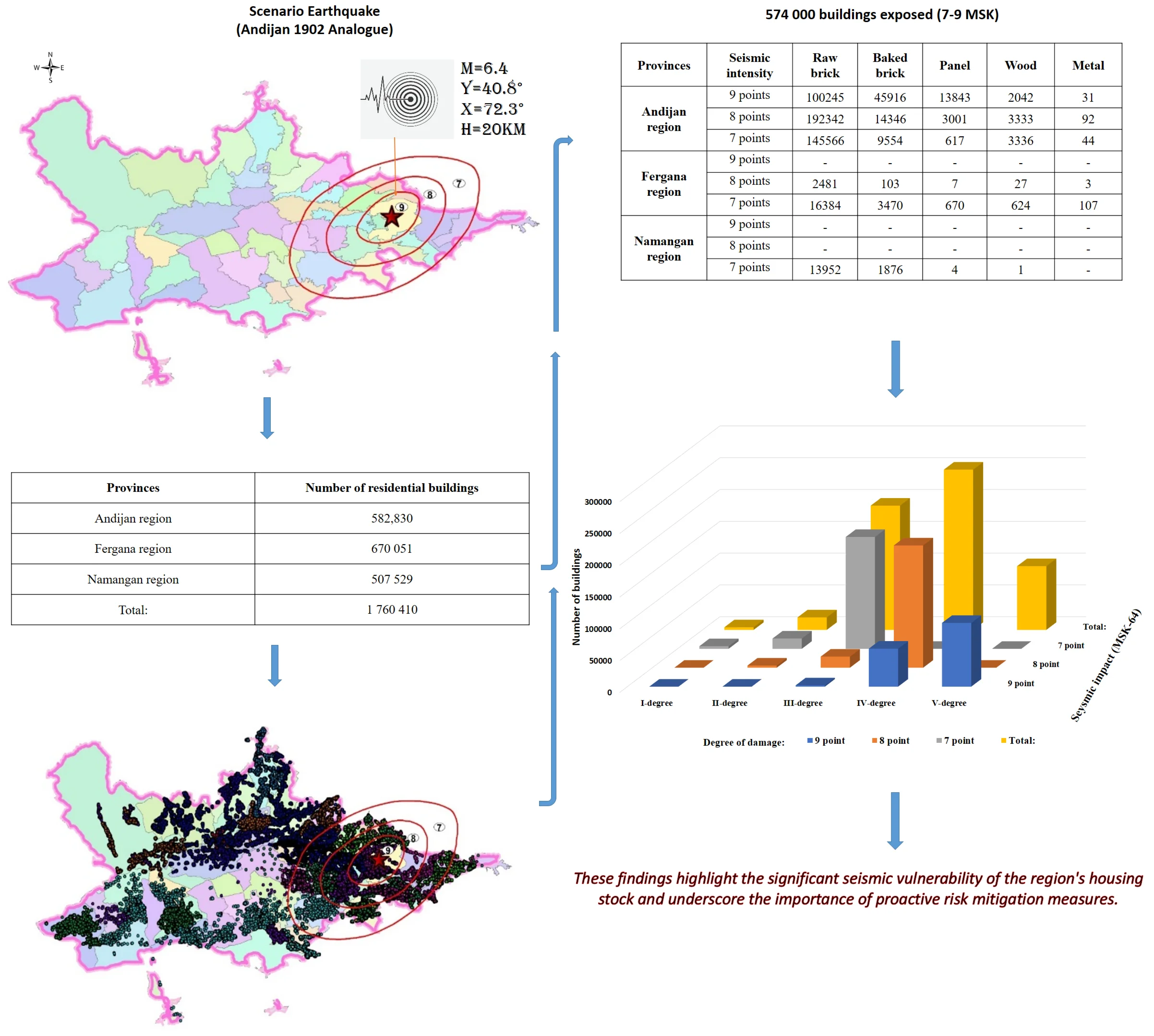
- Identified ~574 000 residential buildings within 7–9 MSK seismic zones for a M 6.4 scenario.
- Produced probabilistic damage maps showing 352 000 buildings at Grade IV–V damage levels.
- Proposed risk-reduction strategies supporting regional seismic resilience and urban-planning policies.
1. Introduction
Uzbekistan is located in one of the most seismically active regions of Central Asia. Among its territories, the Fergana Valley is particularly vulnerable to strong earthquakes, historically experiencing seismic intensities reaching 8-9 on the MSK-64 scale. A notable event, the Andijan earthquake (1902, 6.5, 9), caused catastrophic damage and loss of life. Despite significant progress in seismic monitoring, a systematic assessment of regional housing vulnerability remains insufficient [1].
Therefore, this research aims to develop a scenario-based model to evaluate the extent of potential earthquake damage to residential buildings in the Fergana Valley. The study aligns with current global efforts to quantify seismic risk through probabilistic and deterministic modeling and provides local insights into the spatial distribution of expected damage. Unlike previous studies that primarily focused on seismic hazard zoning, this paper integrates cadastral housing data with digital seismic scenario modeling, offering a region-specific framework for disaster risk reduction [1-5].
2. Methodology
The scientific, methodological, and practical aspects of seismic risk assessment – including seismic hazard, seismic impact, and the vulnerability levels of buildings – have been widely discussed in previous studies [9-13]. This research combines scenario-based seismic risk modeling in the “Extremum” software with local data for five main building types in the region.
Selection of the Seismic Scenario. A historically confirmed earthquake – the 1902 Andijan event ( 6.5, depth = 9 km, 9 MSK) – was selected as the representative seismic scenario. As a result, a realistic spatial distribution of macroseismic intensity across the Fergana Valley was obtained, serving as the foundation for subsequent seismic risk assessments.
Building Database and Typological Classification. Based on cadastral data provided by the State Committee on Land Resources of the Republic of Uzbekistan, a total of 1,760,410 residential buildings were identified across the Andijan, Fergana, and Namangan regions.
Each building was classified into one of the five main structural types reflecting the region’s construction practices and materials: raw brick, baked brick, panel, wood, metal.
For each typology, a vulnerability class (A-E) was assigned according to the European Macroseismic Scale (EMS-98) and calibrated using local data on actual seismic performance from historical earthquakes.
Ground Motion Modeling and Soil Classification. Ground motion fields were simulated using the “Extremum” software, incorporating soil amplification factors derived from engineering – geological studies.
The area was divided into three soil types (I-III) according to their stiffness and damping characteristics. Consequently, peak ground accelerations (PGA) were adjusted to obtain realistic shaking intensity distributions, resulting in seismic zoning maps within the 7-9 MSK range.
Innovation and Distinctiveness of the Study. The novelty of this research lies in its integration of analytical modeling and scenario-based seismic risk assessment specifically calibrated for the Fergana Valley – a densely populated and seismically active region. Also, the study:
– Introduces a five-category typological classification reflecting local construction practices.
– Develops, for the first time, probabilistic damage and loss maps for the Fergana Valley.
This integrated approach improves the accuracy of seismic loss estimation and provides an essential decision-support tool for regional risk mitigation and urban planning.
3. Results
According to information provided by the Cadastral Agency as of March 1, 2025, a total of 1,760,410 residential units were listed in the Andijan, Fergana, and Namangan regions (Table 1).
Table 1Housing stock in the Fergana Valley regions
Provinces | Number of residential buildings |
Andijan region | 582,830 |
Fergana region | 670 051 |
Namangan region | 507 529 |
Total: | 1 760 410 |
Fig. 1Earthquake isoseist map with scenario y= 40.80; x= 72.30; H= 20 km; M= 6.4. Source: Database of the Institute of Seismology
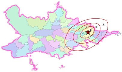
Fig. 2Map of existing residential buildings in the Fergana Valley regions. Source: Database of the Institute of Seismology

Using the SeismicRiskAssessment v3.0 software, an assessment was conducted to estimate the damage to existing residential buildings in the Fergana Valley regions under the impact of a potential strong earthquake. The scenario earthquake was modeled with the following parameters: latitude 40.80, longitude 72.30, depth 20 km, and magnitude 6.4. The results of the simulation are presented in Figs. 1 and 2.
According to the results of the analysis, out of the 1,760,410 existing residential buildings, a total of 574,017 are located in seismic zones with intensities of 7, 8, and 9 points on the MSK-64 scale. Specifically, 196,205 buildings fall within the 7-point zone, 215,735 buildings in the 8-point zone, and 162,077 buildings in the 9-point zone. Regionally, the distribution is as follows: Andijan region – 534,308 buildings; Fergana region – 23,876 buildings; and Namangan region – 15,833 buildings.
Table 2Number of residential buildings in the Fergana Valley regions under various seismic effects
Provinces | Seismic intensity | Raw brick | Baked brick | Panel | Wood | Metal |
Andijan region | 9 points | 100245 | 45916 | 13843 | 2042 | 31 |
8 points | 192342 | 14346 | 3001 | 3333 | 92 | |
7 points | 145566 | 9554 | 617 | 3336 | 44 | |
Fergana region | 9 points | – | – | – | – | – |
8 points | 2481 | 103 | 7 | 27 | 3 | |
7 points | 16384 | 3470 | 670 | 624 | 107 | |
Namangan region | 9 points | – | – | – | – | – |
8 points | – | – | – | – | – | |
7 points | 13952 | 1876 | 4 | 1 | – |
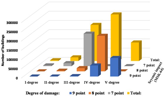
A total of 352,346 residential buildings are expected to sustain Grade IV and V damage levels based on the criteria of the MSK-64 International Macroseismic Scale (see Table 2). Thе damage to the housing stock is classified into five degrees of severity: Degree 1, Degree 2, Degree 3, Degree 4, and Degree 5 (refer to Fig. 3).
Fig. 3Degrees of damage to the housing stock
4. Discussion
The Fergana Valley is one of the most seismically active regions of Uzbekistan and is at significant risk of strong earthquakes. Historical records indicate that the region has experienced multiple earthquakes with intensities reaching 8 to 9 on the МSK-64 scalе. Notable sеismiс events include thе Fergana earthquake (838), Namangan (1494), Andijan (1907), Aim (1903), Namangan (1908, 1912, 1927), Yartepa (1942), Isfara-Batken (1977), Khaidarkan (1977), and Pop (1984) earthquakes [4-7, 11-18].
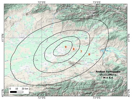
Among these, the most devastating was the Andijan earthquake of December 15, 1902, which had a magnitude of 6.4. This event resulted in the destruction of over 40,000 houses and claimed the lives of more than 4,500 people (see Fig. 4) [8].
According to the earthquake recurrence hypothesis, often referred to as the seismic gap theory, there is significant concern about the potential for future large earthquakes in the Fergana Valley. This potential poses significant risks, including substantial economic losses, social disruption, and increased environmental challenges in the region [12, 18-23].
To mitigate these risks, it is essential to strictly adhere to seismic stability standards in construction practices, regularly educate the population on earthquake safety measures, and implement key strategies such as the development and deployment of early warning systems [6, 20, 23-27].
Fig. 4Isoseismal map of the 1902 Andijan earthquake (based on data from the Institutе of Sеismоlogy, Acadеmy оf Sciences of the Rеpublic of Uzbеkistan)
5. Conclusions
The potential damage to buildings and structures resulting from strong earthquakes in the Fergana Valley – a densely populated and highly seismically active region of the Republic – was assessed using the SeismicRiskAssessment v3.0 software.
Based on a scenario earthquake with parameters 40.80, 72.30, 20 km, and 6.4, a total of 574,017 residential buildings (out of 1,760,410) were identified within seismic impact zones of 7, 8, and 9 points on the MSK-64 scale. The projected damage levels to these buildings are as follows: Level V damage – 100,245 buildings, Level IV damage – 252,101 buildings, Level III damage – 195,432 buildings, Level II damage – 19,646 buildings, Level I damage – 4,112 buildings
These findings highlight the significant seismic vulnerability of the region's housing stock and underscore the importance of proactive risk mitigation measures.
References
-
V. Ismailov, S. Khusomiddinov, A. Khusomiddinov, S. Yodgorov, B. Aktamov, and S. Avazov, “Seismic risk assessment of Jizzakh region,” in 2021 Asia-Pacific Conference on Applied Mathematics and Statistics, Vol. 2471, No. 1, p. 030035, Jan. 2022, https://doi.org/10.1063/5.0089664
-
V. A. Ismailov, S. I. Yodgorov, A. S. Khusomiddinov, E. M. Yadigarov, A. S. Botirovich, and B. U. Aktamov, “New classification of soils by seismic properties for the building code in Uzbekistan,” Geomechanics and Geoengineering, Vol. 19, No. 4, pp. 605–625, Jul. 2024, https://doi.org/10.1080/17486025.2023.2296975
-
S. Tyagunov, S. Vorogushyn, C. Muñoz Jimenez, S. Parolai, and K. Fleming, “Multi-hazard fragility analysis for fluvial earthen dikes in earthquake and flood prone areas,” Natural Hazards and Earth System Sciences, Vol. 18, No. 9, Aug. 2017, https://doi.org/10.5194/nhess-2017-287
-
T. U. Artikov, R. S. Ibragimov, T. L. Ibragimova, and M. A. Mirzaev, “Study of modern seismic zoning maps’ accuracy (case for Eastern Uzbekistan),” Geodesy and Geodynamics, Vol. 7, No. 6, pp. 416–424, Nov. 2016, https://doi.org/10.1016/j.geog.2016.04.015
-
V. A. Ismailov, Sh. I. Yadigarov, A. S. Khusomidinov, E. M. Yadigarov, B. U. Aktamov, and Sh. B. Avazov, “Assessment of seismic risk for the territory of Uzbekistan,” Problems of Engineering Seismology, Vol. 50, No. 4, pp. 5–24, Jan. 2023, https://doi.org/10.21455/vis2023.4-1
-
T. U. Artikov, R. S. Ibragimov, T. L. Ibragimova, and M. Mirzaev, “Complex of general seismic zoning maps OSR-2017 of Uzbekistan,” Geodesy and Geodynamics, Vol. 11, No. 4, pp. 273–292, Jul. 2020, https://doi.org/10.1016/j.geog.2020.03.004
-
T. U. Artikov, R. S. Ibragimov, T. L. Ibragimova, M. A. Mirzaev, and Y. L. Rebetsky, “Stress state of the earth’s crust, seismicity, and prospects for long-term forecast of strong earthquakes in Uzbekistan,” Russian Geology and Geophysics, Vol. 63, No. 12, pp. 1442–1458, Dec. 2022, https://doi.org/10.2113/rgg20214408
-
T. U. Artikov, R. S. Ibragimov, T. L. Ibragimova, and M. A. Mirzaev, “Models of the macroseismic field earthquakes and their influence on seismic hazard assessment values for Central Asia,” Geodynamics and Tectonophysics, Vol. 11, No. 3, pp. 606–623, Sep. 2020, https://doi.org/10.5800/gt-2020-11-3-0494
-
A. Calderon and V. Silva, “Probabilistic seismic vulnerability and loss assessment of the residential building stock in Costa Rica,” Bulletin of Earthquake Engineering, Vol. 17, No. 3, pp. 1257–1284, Oct. 2018, https://doi.org/10.1007/s10518-018-0499-1
-
V. Ismailov, B. Aktamov, and Sh. Allayev, “Methodology for assessing the consequences of a strong earthquake for urban areas,” Journal of Civil Protection, Vol. 4, No. 3, pp. 305–315, Jul. 2020, https://doi.org/10.33408/2519-237x.2020.4-3.305
-
V. A. Ismailov, S. I. Yodgorov, A. S. Khusomiddinov, E. M. Yadigarov, B. U. Aktamov, and S. B. Avazov, “Regional seismic risk assessment based on ground conditions in Uzbekistan,” Natural Hazards and Earth System Sciences, Vol. 24, No. 6, pp. 2133–2146, Jun. 2024, https://doi.org/10.5194/nhess-24-2133-2024
-
V. A. Ismailov, S. I. Yodgorov, S. B. Allayev, T. U. Mamarozikov, and S. B. Avazov, “Seismic microzoning of the Tashkent territory based on calculation methods,” Soil Dynamics and Earthquake Engineering, Vol. 152, p. 107045, Jan. 2022, https://doi.org/10.1016/j.soildyn.2021.107045
-
A. Khusomiddinov, S. Yodgorov, F. Sadirov, E. Yadigarov, B. Aktamov, and S. Avazov, “Estimation of the seismic intensity increments in Tashkent region,” in 2021 Asia-Pacific Conference on Applied Mathematics and Statistics, Vol. 2471, p. 030034, Jan. 2022, https://doi.org/10.1063/5.0089662
-
V. A. Ismailov, A. S. Khusomiddinov, S. I. Yodgorov, E. M. Yadigarov, and B. U. Aktamov, “Seismic microzonation map of the territory of Yangi – Andijan: methodology and results,” Series of Geology and Technical Sciences, Vol. 2, No. 464, pp. 114–130, Apr. 2024, https://doi.org/10.32014/2024.2518-170x.397
-
S. Moradi, M. M. Khan, N. U. I. Hossain, M. Shamsuddoha, and A. Gorod, “Modeling and assessing seismic resilience leveraging systems dynamic approach: A case study of society 5.0,” International Journal of Critical Infrastructure Protection, Vol. 43, p. 100639, Dec. 2023, https://doi.org/10.1016/j.ijcip.2023.100639
-
A. Abarca and R. Monteiro, “Towards large scale seismic risk assessment in Algeria: case study to the city of Blida,” in IOP Conference Series: Materials Science and Engineering, Vol. 603, No. 5, p. 052065, Sep. 2019, https://doi.org/10.1088/1757-899x/603/5/052065
-
D. Feliciano, O. Arroyo, T. Cabrera, D. Contreras, J. A. Valcárcel Torres, and J. C. Gómez Zapata, “Seismic risk scenarios for the residential buildings in the Sabana Centro province in Colombia,” Natural Hazards and Earth System Sciences, Vol. 23, No. 5, pp. 1863–1890, May 2023, https://doi.org/10.5194/nhess-23-1863-2023
-
A. Yuvmitov, D. Akhundjanov, U. Abdurakhmanov, N. Khasanova, and B. Egamberdiev, “Study of stress-strain state of structures and assessment of seismic safety of Ismoil Somoni Mausoleum in Bukhara,” in E3S Web of Conferences, Vol. 452, p. 06007, Nov. 2023, https://doi.org/10.1051/e3sconf/202345206007
-
A. Peresan, C. Scaini, S. Tyagunov, and P. Ceresa, “capacity building experience for disaster risk reduction in central Asia,” Natural Hazards and Earth System Sciences Discussions, Sep. 2023, https://doi.org/10.5194/nhess-2023-156
-
L. Martins, V. Silva, H. Crowley, and F. Cavalieri, “Vulnerability modellers toolkit, an open-source platform for vulnerability analysis,” Bulletin of Earthquake Engineering, Vol. 19, No. 13, pp. 5691–5709, Jul. 2021, https://doi.org/10.1007/s10518-021-01187-w
-
M. R. Valluzzi, V. Follador, and L. Sbrogiò, “Vulnus web: a web-based procedure for the seismic vulnerability assessment of masonry buildings,” Sustainability, Vol. 15, No. 8, p. 6787, Apr. 2023, https://doi.org/10.3390/su15086787
-
N. I. Frolova, S. P. Suchshev, A. N. Ugarov, and N. S. Malaeva, “Updated indicators of seismic risk for the territory of the Irkutsk region and the Republic of Buryatia,” Russian Journal of Seismology, Vol. 5, No. 1, pp. 26–50, Mar. 2023, https://doi.org/10.35540/2686-7907.2023.1.02
-
R. S. Ibragimov, T. L. Ibragimova, M. A. Mirzaev, and Y. L. Rebetsky, “The probability of a strong (M≥6.0) earthquake in the south Fergana seismic activity zone in the coming years,” Geodynamics and Tectonophysics, Vol. 14, No. 1, Feb. 2023, https://doi.org/10.5800/gt-2023-14-1-0688
-
K. Koohfallah, M. Raissi Dehkordi, D. D. ’Ayala, G. Ghodrati Amiri, M. Eghbali, and D. Samadian, “Seismic resilience of typical steel school building and retrofitting options based on FEMA P-58 under mainshock-aftershock effects,” Journal of Building Engineering, Vol. 86, p. 108636, Jun. 2024, https://doi.org/10.1016/j.jobe.2024.108636
-
V. A. Ismailov, J. S. Bozorov, A. S. Khusomiddinov, E. M. Yadigarov, and A. F. Mansurov, “Determination of changes in soil parameters using the plaxis 3D program using reinforcement of bored piles,” NEWS of The Academy of Sciences of the Republic of Kazakhstan Series of Geology and Technical Sciences, Vol. 3, No. 471, Jun. 2025, https://doi.org/10.32014/2025.2518-170x.461
-
E. Yadigarov, A. Khusomiddinov, A. Mansurov, and K. Islamov, “Question on the necessity of seismic microzonation in urban areas (on the example of Gulistan city),” in 6th International Conference for Physics and Advance Computation Sciences: ICPAS2024, Vol. 3282, No. 1, p. 040008, Jan. 2025, https://doi.org/10.1063/5.0265087
-
J. Bozorov, N. Oripov, E. Yadigarov, and A. Xusomiddinov, “Assessment of seismic impact change through engineering-technical reinforcement of loess soils,” in 6th International Conference for Physics and Advance Computation Sciences: ICPAS2024, Vol. 3282, No. 1, p. 040003, Jan. 2025, https://doi.org/10.1063/5.0265140
About this article

This research was conducted within the framework of the fundamental and innovative development projects of the Academy of Sciences of the Republic of Uzbekistan, Seismology Institute: “Assessment of various levels of seismic hazard in seismically active regions and development of scientific foundations for reducing earthquake losses”; project #ALM202311142839, “Creation of a digital simulation model of Tashkent city for evaluating economic losses and damage levels caused by strong earthquakes”; and project #AL-8924073457, “Development of a macroseismic database platform for analyzing damage to buildings and structures in epicentral zones during strong earthquakes”.
The datasets generated during and/or analyzed during the current study are available from the corresponding author on reasonable request.
The authors declare that they have no conflict of interest.
