Abstract
In order to analyze the stability of subgrade slope and explore the deformation and failure mechanism of slope, so as to guide the dynamic construction of expressway engineering and ensure the safety of construction site and the safe operation of highway. In this paper, PLAXIS 2D finite element analysis model is established based on the slope classification excavation project of Yuxiang double line expressway project, and the stability of slope classification excavation and rainfall conditions is studied. The calculation results show that: 1) After two excavations, the soil on the top of the slope is reduced and the safety factor of the slope is improved; After two excavations, the soil on the top of the slope is reduced and the safety factor of the slope is improved. 2) In the aspect of excavation, the protection setting of window-hole retaining wall is unreasonable, and the plastic points of soil near the anti-slide pile are concentrated, which may lead to plastic failure. 3) Under rainfall conditions, the overall deformation of the slope develops towards the toe of the slope. During the construction process, temporary protection should be set at the toe of the slope.
1. Introduction
As an important transportation hub connecting towns and cities, expressways play an irreplaceable role in facilitating people's travel and transportation. With the important strategic deployment of the western development, the construction speed of expressways in western China has been continuously improved, and the traffic lines have become more and more intensive. As one of the common geological structures in expressway engineering, the stability evaluation of subgrade slope has attracted wide attention of scholars [1].
The increase of pore water pressure inside the slope caused by rainfall is a major factor in the occurrence of landslides. In the study of rainfall infiltration law, scholars at home and abroad have gradually formed a rich theoretical system for slope stability analysis and calculation [2-5]. Duncan [6] points out that the slope safety factor can be defined as the degree of reduction of the shear strength of the soil when the slope just reaches the critical failure state, that is, the safety factor is defined as the ratio of the actual shear strength of the soil to the reduced shear strength at the critical failure. Ouyang et al. [7] modified the M-P method by Gauss quadrature method. This method improves the computational efficiency and provides a reference for other integral problems in geotechnical engineering. Cao et al. [8] improved the meshless numerical manifold method (MNMM) for slope stability analysis, which overcomes the dependence and sensitivity of the finite element strength reduction method on the number of finite element meshes and the solution algorithm of nonlinear equations when calculating the slope with weak interlayer.
As far as Chongqing area is concerned, its complex terrain and changeable geological conditions make it more difficult to evaluate the stability of subgrade slope. Many designers have a simple understanding of the mechanism of slope instability when evaluating the stability of slope, and blindly apply other engineering experience [9]. Therefore, this paper uses PLAXIS 2D software to establish a finite element analysis model to study the stability of subgrade slope under graded excavation and rainfall conditions, aiming to guide the dynamic construction of expressway engineering and ensure the safety of construction site and the safe operation of highway.
2. Project profile
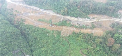
The project is located in the Wulong-Daozhen section of the Yuxiang double-track expressway project. The K19 + 314.265 ~ K19 + 604.419 section is the starting section of the Wujiapo Bridge. The right side slope of this section is about 30 m high and the total length is about 209 m. The design scheme is “anti-slide pile + two-stage step-by-step protective wall”. The step height of the slope is 10 m, the step slope ratio is 1: 1.25, and the slope aspect is 90 °. The self-stability of the slope is poor, and the excavated slope is easy to slide along the rock-soil interface. The slope plan is shown in Fig. 1.
Fig. 1Aerial photograph of Wujiapo Bridge
The survey area belongs to the structural erosion gully slope landform, the natural slope angle is 20°-30°, and the trailing edge is a cliff. The slope rate of the original slope formed by the current excavation is 1: 1.25, and the height difference of each step is about 10 m. According to the current situation investigation and data collection, the distribution strata in the survey area are mainly Cenozoic Quaternary Holocene colluvial layer, Lower Silurian Longmaxi Formation (S1l), Lower Ordovician Tongzi Formation (O1t). The lithology of each stratum from new to old is described as follows:
Gravel-bearing silty clay: yellow-brown to gray-brown, plastic, mainly composed of clay powder particles, containing about 30 % gravel, angular, mainly shale and limestone. The thickness is 3-10 m, mainly distributed in the relatively flat terrain.
Gravel soil: gray, grayish brown. The gravel is mainly composed of strongly weathered silty shale and limestone. The general particle size is 20 mm-200 mm, and the local part is greater than 200 mm. The rest is filled with silt and clay, slightly dense to dense, wet to saturated, and has good water permeability.
Limestone: gray, mainly composed of calcite minerals, cryptocrystalline structure, medium-thick layered structure, partially intercalated with shale and sandstone.
Slope excavation on slope deposits leads to local instability of the slope, and small-scale soil collapse is seen in many places. The cliff at the back edge of the slope is a dangerous rock zone, and the structural plane of the rock mass forms an unfavorable combination with the slope surface, and many dangerous rock masses are developed. In addition to the dangerous rock (collapse) and soil collapse described above, there are no other bad geological phenomena such as landslide, dangerous rock (collapse) and debris flow in the area.
3. Establishment of numerical model
3.1. Selection of constitutive model
In this paper, PLAXIS 2D software is used to calculate and analyze the stability of subgrade slope under graded excavation and rainfall conditions. The classical Mohr-Coulomb constitutive model is used in the soil solid element and interface element in the analysis model. The model can well express the shear failure characteristics of soil and interface materials. The construction support structure is simulated by plate element. Due to the difference in shear strength between anti-slide pile and slope soil under the action of slope excavation and rainfall seepage, the “interface element” can be set on the contact surface of the two to connect.
3.2. Model construction
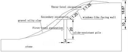
In this numerical simulation, according to the site conditions of the slope project, the actual section size of the slope is selected to establish a geometric calculation model. The height of the subgrade from the slope top is 28.87 m, and the anti-slide pile is embedded in the surface of the subgrade for 10 m, and the section is appropriately simplified. The geometric calculation model is shown in Fig. 2.
Fig. 2Geometric calculation model
3.3. Model material parameters
According to the geological survey report of the engineering site, the physical and mechanical parameters of the rock and soil used in the finite element numerical calculation are shown in Table 1.
Table 1Physical and mechanical parameters of slope rock and soil mass
Category | Gravel silty clay | Stone |
Natural gravity (kN/m3) | 22 | 23 |
Saturation weight (kN/m3) | 22.5 | 23.5 |
Elastic modulus (MPa) | 16.1 | 62 |
Poisson ratio | 0.3 | 0.33 |
Cohesion (kPa) | 24 | 53 |
Internal friction angle (°) | 21 | 30 |
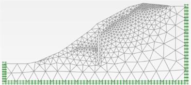
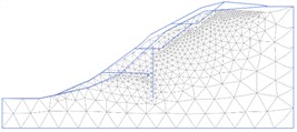
3.4. Grid division and boundary conditions
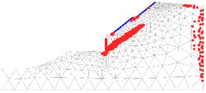
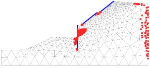
Fig. 3 is the model grid division diagram, the grid density is set to medium, and the enhanced grid refinement is selected. The soil grid division at the slope excavation surface is encrypted to improve the calculation accuracy. A total of 970 units and 8001 nodes are generated. The boundary conditions of horizontal fixed constraints, horizontal and vertical fixed constraints at the bottom of the slope are set on both sides of the model slope.
3.5. Simulation condition setting
According to the data, the annual rainfall in Wulong District of Wulong District is mainly concentrated in May to September, accounting for more than 80 % of the annual rainfall. The average monthly rainfall from 2008 to 2022 was 254.12 mm, the maximum daily rainfall was 124.25 mm, and the number of months with 150 mm rainfall was 3 times a year. In this numerical analysis, the maximum single-day rainfall of 120 mm is selected for calculation, and only one rainfall event is set. The rainfall duration is 4 hours and the rainfall intensity is 30 mm/h.
Fig. 3Model grid division
4. Numerical simulation results and analysis
According to the survey report data, the area where the Wujiapo Bridge is located belongs to the structural erosion dissolution landform. There is about five months of rainy season every year, and the main disasters are flash floods and hail. In order to summarize and analyze the genetic mechanism and structural characteristics of the slippery strata in this area, it is necessary to support the stability evaluation of the subgrade slope, guide the dynamic construction of the slope project, study the deformation mechanism of the subgrade slope under excavation and rainfall conditions, and reveal the evolution law of the deformation and instability of the subgrade slope induced by excavation.
4.1. Slope stability analysis under graded excavation conditions
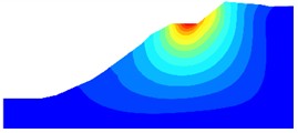
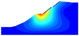
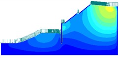
The safety factor is the most valuable parameter for slope stability evaluation. In the natural state of the slope, the total displacement and deformation of the soil under gravity load are shown in Fig. 4. It can be seen that the slope has a large deformation at the top of the slope, which is mainly manifested as downward settlement. The maximum displacement is 31.05 cm, and there is no potential slip surface. The slope soil is basically in a stable state. However, it can be seen from Table 2 that the safety factor of the slope is low in the natural state, only 1.269. Human engineering activities or rainstorm conditions may still cause disturbance to the slope, reduce the slope safety factor, and cause slope sliding deformation.
Fig. 4Total displacement and deformation grid of natural slope
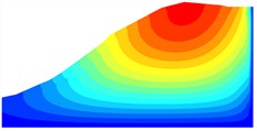
a) Total displacement
b) Deforming mesh
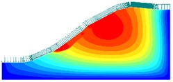
According to Table 2, after the three-stage excavation of the slope, the safety factor does not change significantly. After the excavation surface is protected by the window-hole retaining wall, the safety factor is slightly improved. Combined with Fig. 5, it can be seen that the slope soil is re-adjusted and balanced, and some unstable factors are eliminated, and the safety factor is maintained. After the secondary excavation of the slope, the safety factor has been significantly improved. Similarly, after the excavation surface is protected by the window-hole retaining wall, the safety factor is slightly improved. Combined with Fig. 5, it can be seen that after two excavations, the overlying soil of the slope is reduced, so that the stability of the slope is improved, but the protective structure after two excavations does not have a significant impact on the safety factor of the slope, and the protection setting is unreasonable. After the first-level excavation of the slope, the safety factor is reduced to 1.080. Combined with Fig. 5 and Fig. 6, it can be seen that the support area of the slope decreases, the overlying soil may undergo plastic failure along the sliding surface, and the risk of instability increases. Therefore, the anti-slide pile is set up for support, and the safety factor of the slope reaches 1.542. Although the supporting structure has achieved obvious results, the plastic points near the anti-slide pile are too concentrated, and the optimization of the anchor cable can be considered.
Table 2The safety factor of each stage of slope grading excavation
Phase | Safety factor (F) |
Raw state | 1.269 |
Three-level excavation (unsupported) | 1.267 |
Three-level excavation (support) | 1.273 |
Secondary excavation (unsupported) | 1.417 |
Secondary excavation (support) | 1.420 |
First-level excavation (unsupported) | 1.080 |
First-level excavation (supported) | 1.542 |
Fig. 5Total displacement of slope grading excavation
a) Three level total displacement (unsupported)
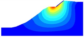
b) Three-level total displacement (support)
c) Secondary total displacement (unsupported)
d) Secondary total displacement (supported)
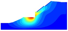
e) The total displacement of the first level (unsupported)
f) The total displacement of the first level (supported)
Fig. 6Plastic point of slope
a) Three-level excavation plastic point (unsupported)
b) Three-level excavation plastic point (supported)
4.2. Slope stability analysis under rainfall conditions
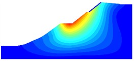
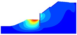
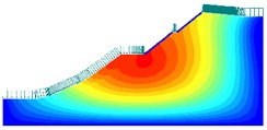
Section 4.1 has discussed the necessity of slope supporting structure, so this section does not carry out the simulation study of slope unsupported. As shown in Fig. 7, in the unexcavated stage of the slope, the influence of rainfall on the displacement of the slope is gradually weakened from the slope to the inside of the slope. After the rainfall, the surface water enters the inside of the slope through seepage, which increases the saturation of the slope soil. As a result, the shear strength of the slope becomes lower, and the overall deformation of the slope develops towards the toe of the slope. The displacement at the maximum deformation is 59.57 cm. In the subsequent excavation stage of the slope, the three-level excavation stage and the two-level excavation stage, after the protection of the window-hole retaining wall, the deformation of the slope has not been improved under the action of rainfall, and the safety factor is low. The slope deformation is mainly affected by the foot of the slope; after the completion of the first-level excavation, the deformation of the slope is obviously improved, the safety factor 1.552, and the soil bulk density of the subgrade surface changes after the rainfall, which improves the soil anti-erosion ability, thus improving the slope safety.
Fig. 7Total displacement of slope after rainfall
a) Total displacement of unexcavated
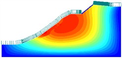
b) Three-level total displacement
c) Secondary total displacement
d) Total first-order displacement
Table 3The safety factor of each stage of slope grading excavation (working condition of rainfall)
Phase | Safety factor () |
Unexcavated | 1.009 |
Three-level excavation (support) | 1.019 |
Secondary excavation (support) | 1.118 |
First-level excavation (support) | 1.552 |
5. Conclusions
Based on the slope grading excavation project of K19 + 314.265 ~ K19 + 604.419 section, this paper establishes a finite element analysis model to study the stability of slope grading excavation and rainfall conditions. The main conclusions are as follows:
1) Under the self-weight load of the slope, the slope top has a large settlement deformation. After two excavations, the soil on the slope top is reduced, the slope safety factor is improved, and the slope stability is improved.
2) It is unreasonable to set the window-type retaining wall on the excavation face. The deformation of the slope mainly occurs in the soil below the excavation face, and the anti-slide pile or anti-slide retaining wall can be considered. The plastic points near the anti-slide pile are too concentrated, and the optimization of anchor cable can be considered.
3) Under the condition of rainfall, the overall deformation of the slope develops towards the foot of the slope. Therefore, in the process of engineering construction, temporary protection at the foot of the slope should be set up to prevent accidents and ensure construction safety.
References
-
A. Yao, Y. Gong, Y. Li, T. Tian, and C. Xu, “Mountain-expressway slope safety based on the online monitoring system and fuzzy comprehensive evaluation,” Journal of Testing and Evaluation, Vol. 50, No. 4, pp. 1906–1919, Jul. 2022, https://doi.org/10.1520/jte20210423
-
V.-H. Cao and G.-H. Go, “Stability analysis of random soil-rock mixture slope using an energy-based failure criterion and Monte Carlo simulation,” Engineering Failure Analysis, Vol. 171, p. 109346, Apr. 2025, https://doi.org/10.1016/j.engfailanal.2025.109346
-
Z. Liao, Z. Jiang, K. Ma, Z. Gao, H. Ke, and A. Wei, “Investigation on cumulative response evolution and stability assessment of rock slope under mainshock and aftershocks,” Computers and Geotechnics, Vol. 180, p. 107092, Apr. 2025, https://doi.org/10.1016/j.compgeo.2025.107092
-
V. Menon, S. Anjana, and S. Kolathayar, “Slope stability analyses and design for a telecommunication tower site in kodagu-limit equilibrium and finite element approach with spatial data integration,” International Journal of Geosynthetics and Ground Engineering, Vol. 11, No. 1, Jan. 2025, https://doi.org/10.1007/s40891-025-00614-1
-
Q. Chen, E. Yan, S. Huang, N. Chen, H. Xu, and F. Chen, “Study on slope stability of paleo-clay strength degradation under soaking and wet-dry cycles,” Water, Vol. 17, No. 2, p. 172, Jan. 2025, https://doi.org/10.3390/w17020172
-
J. M. Duncan, “State of the art: limit equilibrium and finite-element analysis of slopes,” Journal of Geotechnical Engineering, Vol. 122, No. 7, pp. 577–596, Jul. 1996, https://doi.org/10.1061/(asce)0733-9410(1996)122:7(577)
-
W. Ouyang, S.-W. Liu, and Y. Yang, “An improved morgenstern-price method using gaussian quadrature,” Computers and Geotechnics, Vol. 148, p. 104754, Aug. 2022, https://doi.org/10.1016/j.compgeo.2022.104754
-
X. Cao, S. Lin, Z. Liang, H. Guo, and H. Zheng, “Meshless numerical manifold method with novel subspace tracking and CSS locating techniques for slope stability analysis,” Computers and Geotechnics, Vol. 166, p. 106025, Feb. 2024, https://doi.org/10.1016/j.compgeo.2023.106025
-
S. M. Hassanizadeh, M. A. Celia, and H. K. Dahle, “Dynamic effect in the capillary pressure-saturation relationship and its impacts on unsaturated flow,” Vadose Zone Journal, Vol. 1, No. 1, p. 38, Jan. 2002, https://doi.org/10.2136/vzj2002.0038
About this article

The authors would like to acknowledge the financial support from the Chongqing Transportation Science and Technology Project (No. CQJT2022ZC20).
The datasets generated during and/or analyzed during the current study are available from the corresponding author on reasonable request.
The authors declare that they have no conflict of interest.
